/1004/site-assets/phone.png)
/1004/site-assets/cart.png)
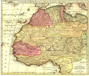
/1004/images/1199207.jpg "Brogan (and Weiser) OR Area USGS 1:24K Topo Map Index")
Brogan Area 1:24K USGS Topo Maps (& Weiser)
SKU: OR-BR24K
$12.00
The 7.5 minute maps by USGS are the most detailed topographic maps of Oregon and are the best tool for figuring out the shape of the land using contour lines. Hills, depressions, cliffs, plateaus, and other physical features are clearly marked on these maps, while colors and symbols indicate whether these hills are wooded or clear. Roads, trails, power lines and shelters are also marked.
Each measures approximately 22" x 27"
Covers about a 6 mile by 9 mile area for each map
USGS Map titles in this region are listed below...
If only ordering 1 or 2 titles, we will fold the maps, ship US Mail and discount the shipping. This discount will not show up until you get the final receipt with the package.
Choose Options
Select...
Becker Creek
Birch Creek Meadow
Brady Creek
Bridgeport
Brogan
Buckbrush Creek
Clover Creek Ranch
Cow Valley East
Cow Valley West
Devils Heel
Henley Basin
Henry Gulch
Hope Butte
Huntington
Ironside
Jamieson
Lime
Little Juniper Spring
Log Creek
Malheur Butte
McCarthy Ridge
Moores Hollow
Mormon Basin
Olds Ferry
Payette
Porters Flat
Rye Valley
Scratch Post Butte
Swede Flat
Tub Mountain
Weiser South
Wendt Butte
Willowcreek
Price each
| Photo | Description | SKU | Units | Price | Qty | |
|---|---|---|---|---|---|---|
/1004/images/1190446.jpg "USGS 7.5 1:24k Brogan Area")
|
Becker Creek | OR-BR24K-00 |
$12.00
|
|
Add to cart
|
|
|
|
Birch Creek Meadow | OR-BR24K-01 |
$12.00
|
|
Add to cart
|
|
|
|
Brady Creek | OR-BR24K-02 |
$12.00
|
|
Add to cart
|
|
|
|
Bridgeport | OR-BR24K-03 |
$12.00
|
|
Add to cart
|
|
|
|
Brogan | OR-BR24K-04 |
$12.00
|
|
Add to cart
|
|
|
|
Buckbrush Creek | OR-BR24K-05 |
$12.00
|
|
Add to cart
|
|
|
|
Clover Creek Ranch | OR-BR24K-06 |
$12.00
|
|
Add to cart
|
|
|
|
Cow Valley East | OR-BR24K-07 |
$12.00
|
|
Add to cart
|
|
|
|
Cow Valley West | OR-BR24K-08 |
$12.00
|
|
Add to cart
|
|
|
|
Devils Heel | OR-BR24K-09 |
$12.00
|
|
Add to cart
|
|
|
|
Henley Basin | OR-BR24K-10 |
$12.00
|
|
Add to cart
|
|
|
|
Henry Gulch | OR-BR24K-11 |
$12.00
|
|
Add to cart
|
|
|
|
Hope Butte | OR-BR24K-12 |
$12.00
|
|
Add to cart
|
|
|
|
Huntington | OR-BR24K-13 |
$12.00
|
|
Add to cart
|
|
|
|
Ironside | OR-BR24K-14 |
$12.00
|
|
Add to cart
|
|
|
|
Jamieson | OR-BR24K-15 |
$12.00
|
|
Add to cart
|
|
|
|
Lime | OR-BR24K-16 |
$12.00
|
|
Add to cart
|
|
|
|
Little Juniper Spring | OR-BR24K-17 |
$12.00
|
|
Add to cart
|
|
|
|
Log Creek | OR-BR24K-18 |
$12.00
|
|
Add to cart
|
|
|
|
Malheur Butte | OR-BR24K-19 |
$12.00
|
|
Add to cart
|
|
|
|
McCarthy Ridge | OR-BR24K-20 |
$12.00
|
|
Add to cart
|
|
|
|
Moores Hollow | OR-BR24K-21 |
$12.00
|
|
Add to cart
|
|
|
|
Mormon Basin | OR-BR24K-22 |
$12.00
|
|
Add to cart
|
|
|
|
Olds Ferry | OR-BR24K-23 |
$12.00
|
|
Add to cart
|
|
|
|
Payette | OR-BR24K-24 |
$12.00
|
|
Add to cart
|
|
|
|
Porters Flat | OR-BR24K-25 |
$12.00
|
|
Add to cart
|
|
|
|
Rye Valley | OR-BR24K-26 |
$12.00
|
|
Add to cart
|
|
|
|
Scratch Post Butte | OR-BR24K-27 |
$12.00
|
|
Add to cart
|
|
|
|
Swede Flat | OR-BR24K-28 |
$12.00
|
|
Add to cart
|
|
|
|
Tub Mountain | OR-BR24K-29 |
$12.00
|
|
Add to cart
|
|
|
|
Weiser South | OR-BR24K-30 |
$12.00
|
|
Add to cart
|
|
|
|
Wendt Butte | OR-BR24K-31 |
$12.00
|
|
Add to cart
|
|
|
|
Willowcreek | OR-BR24K-32 |
$12.00
|
|
Add to cart
|
Brogan Area 1:24K USGS Topo Maps (& Weiser)
Becker Creek
Becker Creek
OR-BR24K-00
Price
$12.00
Quantity
Brogan Area 1:24K USGS Topo Maps (& Weiser)
Birch Creek Meadow
Birch Creek Meadow
OR-BR24K-01
Price
$12.00
Quantity
Brogan Area 1:24K USGS Topo Maps (& Weiser)
Brady Creek
Brady Creek
OR-BR24K-02
Price
$12.00
Quantity
Brogan Area 1:24K USGS Topo Maps (& Weiser)
Bridgeport
Bridgeport
OR-BR24K-03
Price
$12.00
Quantity
Brogan Area 1:24K USGS Topo Maps (& Weiser)
Brogan
Brogan
OR-BR24K-04
Price
$12.00
Quantity
Brogan Area 1:24K USGS Topo Maps (& Weiser)
Buckbrush Creek
Buckbrush Creek
OR-BR24K-05
Price
$12.00
Quantity
Brogan Area 1:24K USGS Topo Maps (& Weiser)
Clover Creek Ranch
Clover Creek Ranch
OR-BR24K-06
Price
$12.00
Quantity
Brogan Area 1:24K USGS Topo Maps (& Weiser)
Cow Valley East
Cow Valley East
OR-BR24K-07
Price
$12.00
Quantity
Brogan Area 1:24K USGS Topo Maps (& Weiser)
Cow Valley West
Cow Valley West
OR-BR24K-08
Price
$12.00
Quantity
Brogan Area 1:24K USGS Topo Maps (& Weiser)
Devils Heel
Devils Heel
OR-BR24K-09
Price
$12.00
Quantity
Brogan Area 1:24K USGS Topo Maps (& Weiser)
Henley Basin
Henley Basin
OR-BR24K-10
Price
$12.00
Quantity
Brogan Area 1:24K USGS Topo Maps (& Weiser)
Henry Gulch
Henry Gulch
OR-BR24K-11
Price
$12.00
Quantity
Brogan Area 1:24K USGS Topo Maps (& Weiser)
Hope Butte
Hope Butte
OR-BR24K-12
Price
$12.00
Quantity
Brogan Area 1:24K USGS Topo Maps (& Weiser)
Huntington
Huntington
OR-BR24K-13
Price
$12.00
Quantity
Brogan Area 1:24K USGS Topo Maps (& Weiser)
Ironside
Ironside
OR-BR24K-14
Price
$12.00
Quantity
Brogan Area 1:24K USGS Topo Maps (& Weiser)
Jamieson
Jamieson
OR-BR24K-15
Price
$12.00
Quantity
Brogan Area 1:24K USGS Topo Maps (& Weiser)
Lime
Lime
OR-BR24K-16
Price
$12.00
Quantity
Brogan Area 1:24K USGS Topo Maps (& Weiser)
Little Juniper Spring
Little Juniper Spring
OR-BR24K-17
Price
$12.00
Quantity
Brogan Area 1:24K USGS Topo Maps (& Weiser)
Log Creek
Log Creek
OR-BR24K-18
Price
$12.00
Quantity
Brogan Area 1:24K USGS Topo Maps (& Weiser)
Malheur Butte
Malheur Butte
OR-BR24K-19
Price
$12.00
Quantity
Brogan Area 1:24K USGS Topo Maps (& Weiser)
McCarthy Ridge
McCarthy Ridge
OR-BR24K-20
Price
$12.00
Quantity
Brogan Area 1:24K USGS Topo Maps (& Weiser)
Moores Hollow
Moores Hollow
OR-BR24K-21
Price
$12.00
Quantity
Brogan Area 1:24K USGS Topo Maps (& Weiser)
Mormon Basin
Mormon Basin
OR-BR24K-22
Price
$12.00
Quantity
Brogan Area 1:24K USGS Topo Maps (& Weiser)
Olds Ferry
Olds Ferry
OR-BR24K-23
Price
$12.00
Quantity
Brogan Area 1:24K USGS Topo Maps (& Weiser)
Payette
Payette
OR-BR24K-24
Price
$12.00
Quantity
Brogan Area 1:24K USGS Topo Maps (& Weiser)
Porters Flat
Porters Flat
OR-BR24K-25
Price
$12.00
Quantity
Brogan Area 1:24K USGS Topo Maps (& Weiser)
Rye Valley
Rye Valley
OR-BR24K-26
Price
$12.00
Quantity
Brogan Area 1:24K USGS Topo Maps (& Weiser)
Scratch Post Butte
Scratch Post Butte
OR-BR24K-27
Price
$12.00
Quantity
Brogan Area 1:24K USGS Topo Maps (& Weiser)
Swede Flat
Swede Flat
OR-BR24K-28
Price
$12.00
Quantity
Brogan Area 1:24K USGS Topo Maps (& Weiser)
Tub Mountain
Tub Mountain
OR-BR24K-29
Price
$12.00
Quantity
Brogan Area 1:24K USGS Topo Maps (& Weiser)
Weiser South
Weiser South
OR-BR24K-30
Price
$12.00
Quantity
Brogan Area 1:24K USGS Topo Maps (& Weiser)
Wendt Butte
Wendt Butte
OR-BR24K-31
Price
$12.00
Quantity
Brogan Area 1:24K USGS Topo Maps (& Weiser)
Willowcreek
Willowcreek
OR-BR24K-32
Price
$12.00
Quantity
You Previously Viewed:
/1004/site-assets/dateseal.jpg "Serving Seattle since 1950")
/1004/site-assets/creditcards.png)