logo
206.623.8747800.727.4430
MENU
logo
0 items | $0.00 | cart
Checkout

NOAA Chart 18429 - Rosario Strait, Southern Part

SKU: NOS18429
$26.95


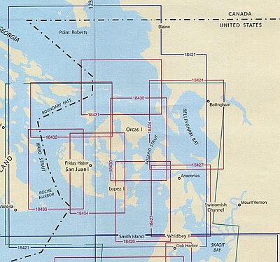
Nautical chart 18429 of Rosario Strait between Lopez & Whidbey Islands, including Decatur Island, Anacortes and tiny Smith Island to the south...plan your trip or decorate your wall with this large nautical chart!

Price each

Photo Description SKU Units Price Qty cart-icon
NOAA Chart 18429 Rosario Strait Southern Part NOAA 1:25,000|35" x 48" NOS18429-
$26.95
Add to cart
You Might Also Like:
Photo Description SKU Units Price Qty cart-icon
San Juan Islands Nautical Chart Book Spiral Bound MapTech San Juan Islands Chartbook by Maptech
12" x 17"|1:33,000/1:89,000
MTCWPCSJ
$79.95
Add to cart
San Juan Islands Index NOAA Nautical Charts San Juan Islands Nautical Charts by NOAA
NOS18400-Strait of Juan de Fuca, Strait of Georgia|1:200,000
NOS18400
$26.95
Add to cart
San Juan Islands Index NOAA Nautical Charts San Juan Islands Nautical Charts by NOAA
NOS18421-Strait of Juan de Fuca to Strait Georgia|1:80,000
NOS18421
$26.95
Add to cart
San Juan Islands Index NOAA Nautical Charts San Juan Islands Nautical Charts by NOAA
NOS18424-Bellingham Bay/Bellingham Harbor|1:40,000
NOS18424
$26.95
Add to cart
San Juan Islands Index NOAA Nautical Charts San Juan Islands Nautical Charts by NOAA
NOS18427-Anacortes to Skagit Bay|1:25,000
NOS18427
$26.95
Add to cart
San Juan Islands Index NOAA Nautical Charts San Juan Islands Nautical Charts by NOAA
NOS18429-Rosario Strait Southern Part|1:25,000
NOS18429
$26.95
Add to cart
San Juan Islands Index NOAA Nautical Charts San Juan Islands Nautical Charts by NOAA
NOS18430-Rosario Strait Northern Part|1:25,000
NOS18430
$26.95
Add to cart
San Juan Islands Index NOAA Nautical Charts San Juan Islands Nautical Charts by NOAA
NOS18431-Rosario Strait to Cherry Pt|1:25,000
NOS18431
$26.95
Add to cart
San Juan Islands Index NOAA Nautical Charts San Juan Islands Nautical Charts by NOAA
NOS18432-Boundary Pass|1:25,000
NOS18432
$26.95
Add to cart
San Juan Islands Index NOAA Nautical Charts San Juan Islands Nautical Charts by NOAA
NOS18433-Haro Strait Mid Bank to Stuart Island|1:25,000
NOS18433
$26.95
Add to cart
San Juan Islands Index NOAA Nautical Charts San Juan Islands Nautical Charts by NOAA
NOS18434-San Juan Channel|1:25,000
NOS18434
$26.95
Add to cart
NOAA Chart 18431 Rosario Strait to Cherry Point NOAA NOAA Chart 18431 - Rosario Strait to Cherry Point
1:25,000|48" x 34"
NOS18431-
$26.95
Add to cart
NOAA Chart 18430 Rosario Strait Northern Part NOAA NOAA Chart 18430 - Rosario Strait, Northern Part
1:25,000|35" x 45"
NOS18430-
$26.95
Add to cart
You Previously Viewed:
logo

logo