/1004/site-assets/phone.png)
/1004/site-assets/cart.png)
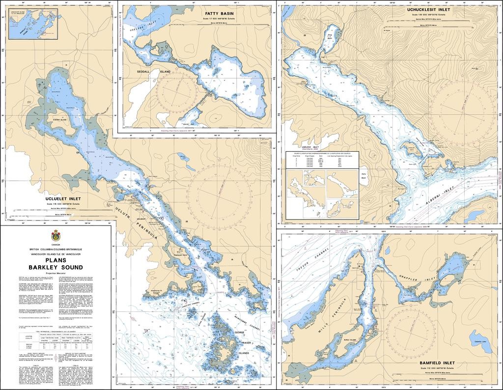
/1004/images/1183835.jpg "Canadian Nautical Chart 3538 Desolation Sound")
Canadian Nautical Chart 3538 l Desolation Sound and Sutil Channel
The Canadian Hydrographic Service (CHS) is instrumental in safeguarding maritime navigation across Canada's waterways, offering a vital array of nautical charts crucial for safe passage.
One such indispensable resource is CHS Chart 3538 Desolation Sound and Sutil Channel.
This official Canadian Hydrographic Nautical Chart provides detailed coverage of key features including Cortes Island, Hernando Island, Malaspina Peninsula, Marina Island, and Refuge Cove.
Known for its accuracy and reliability, CHS Chart 3538 Desolation Sound and Sutil Channel serves as an essential tool for navigators seeking safe transit through these dynamic waterways.
Whether for recreational boating or commercial shipping, this chart offers critical information to enhance situational awareness and mitigate navigational risks.
CHS's commitment to maritime safety is evident in the meticulous detail and usability of CHS Chart 3538, making it an indispensable companion for safe navigation in Canada's coastal regions.
Price each
| Photo | Description | SKU | Units | Price | Qty | |
|---|---|---|---|---|---|---|
/1004/images/1183835.jpg "Canadian Nautical Chart 3538 Desolation Sound")
|
1:40,000|47" x 33" | CHY3538- |
$24.00
|
|
Add to cart
|
|
| You Might Also Like: | ||||||
| Photo | Description | SKU | Units | Price | Qty | |
/1004/images/1183841.jpg "Canadian Nautical Chart 3670 Broken Group")
|
Canadian Nautical Chart 3670 l Broken Group 1:20,000|33" x 47" |
CHY3670- |
$24.00
|
|
Add to cart
|
|
/1004/images/1180992.jpg "Canadian Nautical Chart Index Map for the Strait of Georgia and Vancouver Island")
|
Strait of Georgia/ Desolation Sound/ Gulf Islands Nautical Charts CHY3526-Howe Sound|1:40,000 |
CHY3526 |
$24.00
|
|
Add to cart
|
|
|
|
Strait of Georgia/ Desolation Sound/ Gulf Islands Nautical Charts CHY3541-Approaches to Toba Inlet|1:40,000 |
CHY3541 |
$24.00
|
|
Add to cart
|
|

/1004/site-assets/dateseal.jpg "Serving Seattle since 1950")
/1004/site-assets/creditcards.png)