/1004/site-assets/phone.png)
/1004/site-assets/cart.png)
/1004/images/1201476.jpg "Washington State Raised Relief Map 3D")
/1004/images/1201474.jpg "Washington State Raised Relief Map 3D - Detail")
/1004/images/1201475.jpg "Washington State Raised Relief Map - Detail")
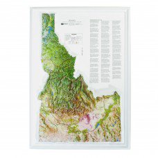
Washington State Raised Relief Map
Washington State Raised Relief Map: Discover the stunning beauty and diversity of Washington State with your own Raised Relief Map, meticulously crafted to capture the essence of the Evergreen State. This molded plastic map provides a three-dimensional perspective of Washington’s topography, showcasing its dramatic mountain ranges, vast lakes, and meandering rivers. Perfect for geography enthusiasts, educators, or anyone who appreciates the natural beauty of Washington, this map combines both functionality and artistic design in a durable, detailed format.
Washington State Raised Relief Map Peaks & Ranges: At the heart of this map are Washington’s iconic mountain ranges and towering peaks. The formidable Cascade Range runs diagonally through the state, featuring the towering Mount Rainier, Washington’s highest peak at 14,411 feet. To the north, the rugged North Cascades offer a dramatic landscape with peaks like Mount Baker and Glacier Peak. The Olympic Mountains, located on the Olympic Peninsula, add to the state’s varied topography with their lush, forested slopes and rugged summits. Each of these mountainous features is meticulously detailed, providing a clear and accurate representation of their elevations and locations.
Washington State Raised Relief Map Geographic Features: This Raised Relief Map also highlights Washington’s diverse geographic features beyond its mountains. The map vividly depicts the state’s major rivers, including the Columbia and the Snake, which carve through the landscape, and its numerous lakes, such as Lake Washington and Lake Chelan. Towns and cities are clearly labeled, making it easy to identify key locations. The map also features the Puget Sound and its intricate coastline, reflecting the region's complex and scenic shorelines.
Washington State Raised Relief Map Scale & Design: Designed with a scale of 1:1,125,000 (approximately 1 inch = 20 miles), this map offers a detailed yet manageable overview of Washington State. Measuring 22” x 17”, it fits perfectly on most walls or desks. Made from molded plastic, it provides a robust and tactile experience, with labeled rivers, lakes, mountains, and towns ensuring all significant features are easy to identify. The raised relief design enhances the visual appeal and adds a tangible dimension to the map, making it not just a functional tool but also a striking decorative piece.
** Raised Relief Maps are printed on vinyl and are not intended to roll and/or fold. We ship them in a flat box and pack them with love (i.e. Plenty of bubble wrap!) **
Price each
| Photo | Description | SKU | Units | Price | Qty | |
|---|---|---|---|---|---|---|
/1004/images/1201476.jpg "Washington State Raised Relief Map 3D")
|
Washington Raised Relief Map - 22" x 17" | AEPWA2217 |
$76.95
|
|
Add to cart
|
|
| You Might Also Like: | ||||||
| Photo | Description | SKU | Units | Price | Qty | |
/1004/images/1190034.jpg "Washington Wall Map Shaded Terrain Large National Geographic Poster")
|
Washington State Wall Map by National Geographic 31" x 41"|Laminated |
NGSWAL |
$35.00
|
|
Add to cart
|
|
/1004/images/1201510.jpg "Olympic National Park Raised Relief Map 3D")
|
Olympic National Park Raised Relief Map Olympic National Park Raised Relief Map - 25" x 18.5" |
AEP417 |
$54.95
|
|
Add to cart
|
|
/1004/images/1201651.jpg "Seattle Area Raised Relief Map by Summit 3D")
|
Seattle Washington / Pacific Northwest Raised Relief Map Seattle / Pacific NW Raised Relief Map - 31.5" x 22"|Unframed |
STIPNWS |
$65.00
|
|
Add to cart
|
|
/1004/images/1201648.jpg "Seattle Area Raised Relief Map by Summit 3D - Black Frame")
|
Seattle Washington / Pacific Northwest Raised Relief Map Seattle / Pacific NW Raised Relief Map - 31.5" x 22"|Black Metal |
STIPNWSFRB |
$238.00
|
|
Add to cart
|
|
/1004/site-assets/dateseal.jpg "Serving Seattle since 1950")
/1004/site-assets/creditcards.png)