/1004/site-assets/phone.png)
/1004/site-assets/cart.png)
/1004/images/1201847.jpg)
Seattle City Street Map l Kroll
SKU: KROSF
$12.95
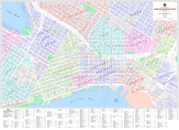
Explore Seattle like never before with the Seattle City Street Map by Kroll Map Company, a local business with over a century of expertise in cartography.
This detailed map includes hundred-block numbers for easy address finding, showing every street within the Seattle city limits and beyond, including parts of Mercer Island. With an inset highlighting street designations, this map covers parks, neighborhoods, schools, and waterways, as well as points of interest.
On the reverse side, you'll find a comprehensive Puget Sound regional arterial map, spanning from Lynnwood and Edmonds to Federal Way and Auburn, and extending east to Bellevue and Issaquah.
The Seattle City Street Map is available in folded paper, rolled paper, or rolled laminated formats, making it perfect for any space.
Whether you're navigating the city or planning your next adventure, this map is an essential tool for both locals and visitors. Add a touch of Seattle history and functionality to your home or office with the Seattle City Street Wall Map from Kroll Map Company.
Whether you're navigating the city or planning your next adventure, this map is an essential tool for both locals and visitors. Add a touch of Seattle history and functionality to your home or office with the Seattle City Street Wall Map from Kroll Map Company.
Price each
| Photo | Description | SKU | Units | Price | Qty | |
|---|---|---|---|---|---|---|
/1004/images/1201856.jpg)
|
Seattle City Street Map / Folded | KROSF |
$12.95
|
|
Add to cart
|
|
/1004/images/1201847.jpg)
|
Seattle City Street Map / 25" x 38" / Paper | KROSR |
$23.95
|
|
Add to cart
|
|
|
|
Seattle City Street Map / 25" x 38" / Laminated | KROSRL |
$35.95
|
|
Add to cart
|
|
| You Might Also Like: | ||||||
| Photo | Description | SKU | Units | Price | Qty | |
/1004/images/161870.jpg)
|
Seattle Detailed Street Map - Large (3'x6') Wall Map 36" x 72"|Laminated|No Zips |
KROSREL |
$149.00
|
|
Add to cart
|
|
/1004/images/1196862.jpg)
|
Seattle Map Book by GM Johnson 8.5" x 11" |
GMJWASEAA |
$21.95
|
|
Add to cart
|
|
/1004/images/167144.jpg)
|
Seattle Laminated Street Map 11 1/4" x 24 1/2" |
GMJWASEAPEARL |
$7.95
|
|
Out of stock
|
|
Price
$12.95
Quantity
Price
$23.95
Quantity
Price
$35.95
Quantity
Price
$149.00
Quantity
Price
$21.95
Quantity
GMJWASEAPEARL
Price
$7.95
Quantity
You Previously Viewed:
/1004/site-assets/dateseal.jpg "Serving Seattle since 1950")
/1004/site-assets/creditcards.png)