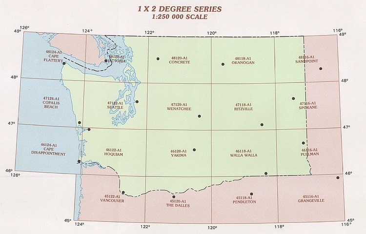
Washington 1:250K Topo Maps
These USGS Washington topographic or contour maps are great maps for getting the "big picture" of an area. These 1:250K scale topographic maps of Washington are all around 18" x 24" (not including the border) and cover 90 x 70 miles with just enough contour detail to give you a basic lay of the land. Water features, towns, primary and secondary roads, railroad lines, mountain peaks, and state and federal boundaries are all marked.

Select...
Name (A to Z)
Name (Z to A)
Price (Low to High)
Price (High to Low)
40
40
80
200
All
Select...
Name (A to Z)
Name (Z to A)
Price (Low to High)
Price (High to Low)
40
40
80
200
All
/1004/site-assets/logo.png)
/1004/site-assets/phone.png)
/1004/site-assets/cart.png)
/1004/images/1190578.jpg)
/1004/images/1190560.jpg)
/1004/images/1190588.jpg)
/1004/images/1191597.jpg)
/1004/images/1191602.jpg)
/1004/images/1191736.jpg)
/1004/images/1191752.jpg)
/1004/images/1191732.jpg)
/1004/images/1192711.jpg)
/1004/images/1192719.jpg)
/1004/images/1192725.jpg)
/1004/images/1192735.jpg)
/1004/images/1192739.jpg)
/1004/images/1192748.jpg)
/1004/images/1192749.jpg)
/1004/images/1192753.jpg)
/1004/images/1192759.jpg)
/1004/images/1192765.jpg)
/1004/site-assets/dateseal.jpg)
/1004/site-assets/creditcards.png)