Oregon 1:24K Topo Maps
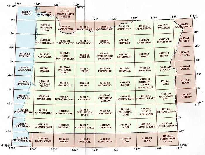
Find the general area for your 7.5' USGS Oregon topographic map, then click on the section title below...

For a list of each area and their titles, click on the images below!
Most map aficionados are familiar with the USGS series, but for those of you who don't know much about them, we're here to help!
These maps, also known as the "7.5 minute maps" are topographical sectionals used by hikers, fishers, hunters and outdoor adventurers.
With the smallest scale available, these are the most detailed maps of Oregon from USGS and are the clearest prints using contour lines.
Hills, Depressions, Cliffs, Plateaus, Roads, Trails, Power Lines and Shelters are a few examples of what is clearly marked on these maps.
The 7.5 minute series measures approximately 22" x 27" and each map area covers about a 6 by 9 mile area.
/1004/site-assets/logo.png)
/1004/site-assets/phone.png)
/1004/site-assets/cart.png)
/1004/images/1199240.jpg)
/1004/images/1199200.jpg)
/1004/images/1199258.jpg)
/1004/images/1199192.jpg)
/1004/images/1199150.jpg)
/1004/images/1199132.jpg)
/1004/images/1199126.jpg)
/1004/images/1199186.jpg)
/1004/images/1199224.jpg)
/1004/images/1199153.jpg)
/1004/images/1199144.jpg)
/1004/images/1199272.jpg)
/1004/images/1199202.jpg)
/1004/images/1199214.jpg)
/1004/images/1199165.jpg)
/1004/images/1199218.jpg)
/1004/images/1199252.jpg)
/1004/images/1199188.jpg)
/1004/images/1199228.jpg)
/1004/images/1199209.jpg)
/1004/images/1199134.jpg)
/1004/images/1199146.jpg)
/1004/images/1199246.jpg)
/1004/images/1199155.jpg)
/1004/site-assets/dateseal.jpg)
/1004/site-assets/creditcards.png)