/1004/site-assets/phone.png)
/1004/site-assets/cart.png)
World Globes and their Advantages
World Globes vs. Paper Maps: The Final Showdown

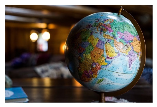
In an age dominated by digital maps and satellite imagery, the humble globe continues to hold a unique significance.
Constructed from materials like plastic, metal, and paper maché, globes represent the Earth in its true spherical form, offering a tactile and accurate portrayal of our planet's geography.
Beyond their aesthetic appeal, globes serve a multitude of purposes across various sectors. Educators rely on them to impart geographic knowledge, scientists employ them for research and visualization, and policymakers utilize them for strategic planning.
Globes bridge the gap between theory and reality, providing a tangible tool to explore the world's complexities and promote global understanding.
Why Globes are so important
Firstly, they provide a three-dimensional representation of the Earth, allowing viewers to see the planet's shape, landmasses, and oceanic features in their true spherical form. This accurate portrayal is crucial for understanding spatial relationships between continents, oceans, and countries, which can be distorted on flat maps due to projection methods. Globes also facilitate the visualization of the Earth's axial tilt, which affects seasonal changes and climate patterns.
Additionally, globes serve practical purposes in fields such as astronomy, meteorology, and navigation. They accurately depict the locations of celestial bodies in relation to the Earth, aiding astronomers in studying the cosmos. Meteorologists use globes to visualize weather patterns and atmospheric circulation, while navigators rely on them for planning routes across oceans and continents.
As symbols of the Earth's unity and diversity, globes encourage environmental stewardship and global citizenship, reminding us of our shared responsibility to protect and preserve our planet for future generations.
What makes a World Globe
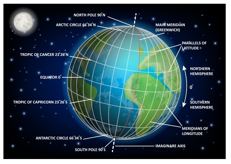
- Base and Mounting: The base of the globe provides stability and may include a mounting mechanism that allows the globe to rotate freely. This rotation capability enables viewers to examine different regions of the Earth easily.
- Axis: The axis of the globe represents the Earth's rotational axis, usually tilted at an angle of 23.5 degrees relative to its orbital plane around the Sun. This tilt causes the seasons and affects the distribution of sunlight across the globe throughout the year.
- Meridian: Meridians are imaginary lines that run from the North Pole to the South Pole, passing through the globe's center. They help establish longitude, enabling users to determine east-west locations on the Earth's surface.
- Equator: The equator is a prominent circle around the middle of the globe, dividing it into the Northern Hemisphere and the Southern Hemisphere. It represents the Earth's widest circumference and serves as the reference point for measuring latitude.
- Latitude Lines: These lines are parallel to the equator and measure distances north and south of it. They indicate the degrees of latitude, with the equator at 0 degrees and the poles at 90 degrees north and south.
- Longitude Lines: Also known as meridians, these lines are perpendicular to the equator and measure distances east and west of the Prime Meridian (0 degrees longitude), which passes through Greenwich, England. Longitude lines help determine specific locations on the Earth's surface.
- Tropic of Cancer and Tropic of Capricorn: These are circles of latitude located at approximately 23.5 degrees north and south of the equator, respectively. They mark the farthest points north and south where the Sun can appear directly overhead during the summer solstice in the Northern Hemisphere and the winter solstice in the Southern Hemisphere.
- Arctic and Antarctic Circles: These circles of latitude are located at approximately 66.5 degrees north and south of the equator, respectively. They represent the latitudes beyond which the Sun does not set on the summer solstice and does not rise on the winter solstice.
- Poles: The North Pole and South Pole are the points where the Earth's axis intersects its surface. They are located at 90 degrees north and south latitude, respectively, and represent the Earth's northernmost and southernmost points.
Understanding these parts of a world globe allows users to visualize and study the Earth's geography, climate patterns, and cultural diversity more effectively.
Globes are valuable tools for education, research, and promoting global awareness and environmental stewardship.

A Few Final Worlds
This realistic portrayal not only enhances geographical literacy but also facilitates a deeper understanding of global phenomena such as climate patterns, ocean currents, and geological formations.
In scientific research, globes are used by geologists, meteorologists, oceanographers, and environmental scientists to study Earth's physical processes and phenomena. They provide a visual framework for analyzing weather patterns, ocean currents, plate tectonics, and biodiversity distribution, contributing to advancements in our understanding of the natural world.
/1004/site-assets/dateseal.jpg "Serving Seattle since 1950")
/1004/site-assets/creditcards.png)