/1004/site-assets/phone.png)
/1004/site-assets/cart.png)
What is a Topographic Map?
What is a Topographic Map? And why are they so important?
Topographic maps are utilized by a diverse range of users, including hikers, geologists, engineers, urban planners, and military personnel.
These maps are crucial because they provide detailed information about the terrain, including elevation, slopes, and landforms, which is essential for navigation, land management, and environmental planning.
Hikers and outdoor enthusiasts rely on them for safe route planning, while geologists and engineers use them to assess land stability and plan construction projects.
Urban planners use topographic maps to design infrastructure and manage natural resources, and the military employs them for strategic planning and operations in varied terrains.
Their detailed depiction of the landscape makes them indispensable for any activity requiring a thorough understanding of the physical environment.
In this article, we'll scratch just the surface as to what a Topographic Map is, who uses them and why!

What is a Topographic Map?
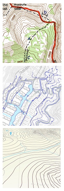
A topographic map, or a topo map, is a two-dimensional representation of the Earth's surface. Unlike other types of maps that focus on political boundaries or road networks, topographic maps prioritize the physical features of an area.
The key lies in the contour lines - the wavy, imaginary lines that wrap around the hills and valleys. These lines represent points of equal elevation and help you visualize the shape and steepness of slopes. By following these contour lines, you can determine whether an area has gentle or steep inclines so you can better plan your next outdoor adventure.
What are Topographic Maps Used for?
Topographic maps have many uses and applications, making them an essential tool for various industries and activities.
- Outdoor activities: These maps are used for hiking, camping, and mountain biking. The maps provide information about elevation contours, helping you to plan your route and anticipate challenging slopes or steep terrain. They also highlight geographical features like rivers, lakes, and forests, helping you confidently navigate different landscapes.
- Urban Planning and Development: Topographic maps are not just for outdoor enthusiasts. City planners and architects use these maps to assess the feasibility of construction projects like roads, bridges, and buildings, analyze the impact on the existing landscape, and determine the best locations for the infrastructure. By understanding the shape of the land and its features, they can make informed construction decisions.
- Agriculture and Land Management: Farmers and landowners use the maps to assess if a given piece of land is suitable for growing crops. They also use it to manage water resources and plan irrigation systems. By understanding the contours and slopes of the land and the terrain, they can implement sustainable farming practices that maximize productivity while minimizing soil erosion.
- Emergency Response and Disaster Management: Emergency teams use these maps to understand the geography of the affected area and plan rescue missions during natural disasters like floods or earthquakes. They can identify safe areas for evacuation, assess the risk of landslides, and determine the best routes to reach those in need.
- Scientific Research and Environmental Studies. Geologists use these maps to analyze the shape of mountains, valleys, and cliffs to learn about the geological history and processes. Also, ecologists rely on topographic maps to identify animal habitats and study how different land features impact biodiversity. Researchers interested in climate change use topo maps to monitor changes in glaciers, water bodies, and other geographical features.
- Marine Navigation. Nautical charts are marine topographic maps. They provide essential information to sailors, fishermen, and other marine enthusiasts. They depict the shape and depth of the ocean floor and highlight other features, such as reefs, shoals, buoys, and lighthouses.
A Brief History of USGS and Topo Maps
The United States Geological Survey (USGS), established in 1879, has played a pivotal role in the development of topographic maps.
Initially tasked with mapping the geological features of the western frontier, the USGS expanded its focus to include detailed topographic mapping of the entire United States.
The first topographic maps were created to aid in the exploration and development of natural resources, as well as to provide valuable information for land use planning, transportation, and defense.
Over the years, the USGS developed standardized symbols and techniques for depicting terrain, including contour lines to represent elevation changes.
These maps became essential tools for a wide range of applications, from scientific research and environmental management to recreation and emergency response.
Today, the USGS continues to innovate in mapping technologies, producing digital topographic maps and geospatial data that support modern navigation and geographic analysis.
Ready to Learn How to Use a Topographical Map?
Topographical maps are different than other maps on the market, so it helps to know how to read and use one effectively.
Well, you're in luck!We created an article specifically on the subject.
Click here How to Read a Topographical Map to learn how to use a topographical map for your next adventure.
/1004/site-assets/dateseal.jpg "Serving Seattle since 1950")
/1004/site-assets/creditcards.png)