/1004/site-assets/phone.png)
/1004/site-assets/cart.png)
The Making of Raised Relief Maps
This article provides an overview of raised relief maps, including the techniques, materials, and processes involved in creating these three-dimensional terrain representations.
An Overview of Raised Relief Maps
Raised relief maps are a unique form of mapping that presents three-dimensional terrain with an exaggerated vertical dimension, offering a tactile and intuitive representation of the world's terrain.
These maps are treasured in visually representing geographic features that can be difficult to understand from a flat map.
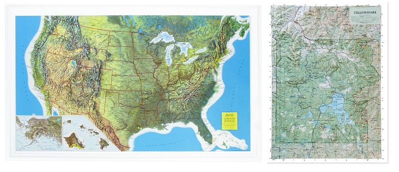
For example, maps of the United States and Yellowstone National Park are exceptional examples of raised relief maps that provide a more intuitive and engaging way to explore the world's terrain, allowing individuals to visualize and comprehend complex topography.
The creation of 3D raised relief maps involves a blend of digital and physical techniques, combining data collection from satellites, LIDAR, and photographs with modern manufacturing processes. This combination allows a more intuitive way to visualize and understand the world's terrain, offering a three-dimensional representation that appeals to people's natural experiences.
By integrating digital data with physical manufacturing methods, 3D-raised relief maps provide a unique and comprehensive view of the earth's landscape, helping individuals better understand various geographic features and terrains.
Understanding 3D Raised Relief Maps
3D raised relief maps are created using digital and physical techniques to offer a tactile, three-dimensional representation of the world's terrain, making them an incredibly engaging tool for exploring and understanding geographic features. These maps visually represent the terrain with exaggerated vertical dimensions, offering a more intuitive way to visualize and comprehend the topography.
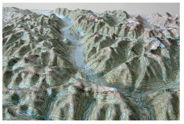
Furthermore, 3D-raised relief maps provide a more captivating and descriptive way to explore terrain, appealing to people's three-dimensional experiences. By incorporating bumps and dips to represent the topography, these maps offer a tactile experience that allows users to feel and visually comprehend the elevation changes of various geographic features.
This tactile representation makes 3D raised relief maps particularly useful for educational settings, as they offer a hands-on approach to learning about the world's terrain, supplementing traditional flat maps with a more engaging and interactive alternative.
With their ability to provide an intuitive representation of terrain, 3D-raised relief maps are invaluable for enhancing geographical understanding and appreciation.
Methods of Creating Raised Relief Maps
The craft of creating raised relief maps has evolved over centuries, with traditional and modern methods playing a crucial role in their construction. Ancient China holds the historical roots of raised relief maps, showcasing the early human inclination towards visually representing three-dimensional terrain.
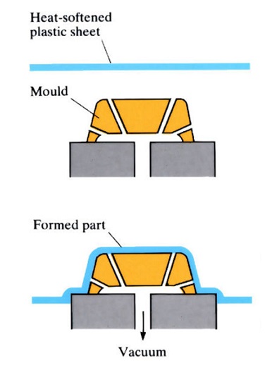
Modern techniques have further advanced the art of crafting these maps in contemporary times. For instance, layer stacking, a process involving assembling various layers to create a 3D effect, and vacuum-formed plastic maps, which utilize heat and vacuum to shape the relief, are widely used methods.
Additionally, 3D printing has revolutionized the creation of raised relief maps, offering a precise and intricate way to replicate topographical features.
Furthermore, these maps extend beyond their traditional role of representing terrain. They have transcended into artistic expressions, as evidenced by the Great Polish Map of Scotland and the Relief Map of Guatemala. These examples showcase the diverse applications and the creative potential of raised relief maps, serving as more than just informational tools.
They have become a unique medium for conveying cultural, historical, and geographical narratives, adding a layer of creativity and aesthetic appeal to their practical purpose. The ability to blend functionality with artistic expression underscores the significance of these maps in both scientific and aesthetic domains.
Materials and Techniques Used
When it comes to creating 3D topography, various materials and techniques are utilized to bring the physical representation of terrain to life. These materials include metal, plastic, wood, 3D printing, and foam, each serving a unique purpose in crafting raised relief maps.
For instance, metal is often used for its durability, allowing for creating sturdy and long-lasting 3D maps. At the same time, plastic offers versatility and ease of manipulation, making it a popular choice for crafting intricate and detailed terrain features.
In addition to the materials used, various techniques play a crucial role in creating raised relief maps. Metal casting, for example, is employed to produce durable and robust 3D terrain representations, ideal for long-term display and educational purposes. On the other hand, 3D printing enables the translation of digital elevation models into physical maps with exceptional precision and intricacy, offering a high level of detail to depict the terrain's features accurately.
Vacuum forming is utilized to mold plastic sheets over carefully crafted molds, resulting in raised relief maps that capture the nuances of the landscape in a visually compelling manner.
Moreover, creating raised relief maps involves meticulous data collection techniques to ensure the accuracy and fidelity of the final representation. This includes utilizing digital elevation models (DEMs) captured through satellite imaging, light detection and range (LIDAR) technology, and detailed photographs of the terrain.
These methods enable mapmakers to capture the intricate details of the landscape, ensuring that the raised relief maps offer an accurate and comprehensive portrayal of the terrain's features, elevations, and topography.
Process of Creating Raised Relief Maps
Creating raised relief maps is a meticulous process that begins with collecting elevation data, which can be obtained through various methods such as satellites, LIDAR, and photographs. Once the necessary data is gathered, the next step involves selecting appropriate materials and techniques for constructing the 3D maps.
These materials include metal, plastic, wood, 3D printing, and foam, which are chosen based on the specific requirements of the map being created.
For example, the map of Yellowstone National Park, one of the stunning examples of raised relief maps, requires precise attention to detail in portraying its unique topography. This involves using materials and techniques that accurately represent the park's distinct features, such as its iconic rock formations and dramatic elevation changes.
Furthermore, creating a raised relief map also involves applying techniques like metal casting, 3D printing, CNC, and vacuum forming, each offering its advantages in bringing the map to life in a tactile and visually engaging manner.
Through carefully selecting materials and the skillful application of construction techniques, raised relief maps are transformed from flat representations into tangible, three-dimensional embodiments of the world's terrain, providing a deeper understanding and appreciation of geographic features.
Examples and Applications of Raised Relief Maps
In addition to the examples mentioned, raised relief maps have found non-terrain applications, further highlighting their versatility and relevance in different fields. One notable example is the Great Polish Map of Scotland, which was not created for navigation or geographical study but as a sculptural art piece in a garden.
This demonstrates how raised relief maps can transcend their traditional usage and be appreciated as artistic installations, blurring the lines between functional representation and aesthetic appeal.
Furthermore, raised relief maps have gained popularity as educational tools, especially in the fields of geography and earth sciences. For instance, the representation of Yosemite National Park in a raised relief map format provides an engaging and tactile way for students and enthusiasts to explore the terrain and understand the area's topographical features.
This application showcases the effectiveness of raised relief maps in simplifying complex geographical information for educational purposes.
Therefore, these examples not only highlight the aesthetic and decorative aspects of raised relief maps but also underscore their educational and informational value in various settings.
/1004/site-assets/dateseal.jpg "Serving Seattle since 1950")
/1004/site-assets/creditcards.png)