/1004/site-assets/phone.png)
/1004/site-assets/cart.png)
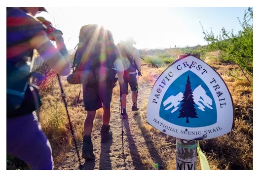
Essential Characteristics of a Good Trail Map
A Comprehensive Guide for Hikers and Outdoor Enthusiasts

A good trail map is an essential tool for hikers and outdoor enthusiasts, providing valuable information about the trail and its surroundings.
It helps hikers navigate safely, plan their route, and maximize their outdoor experience.
In this article, we will explore the essential characteristics of a good trail map, including clear representation of the trail, easy-to-read symbols and legends, scale and distance measurements, topographic information, landmarks and points of interest, trail difficulty ratings, trailhead locations and parking information, trail intersections, and elevation profiles.
Characteristics of a Good Trail Map
Precise and Accurate Representation of the Trail
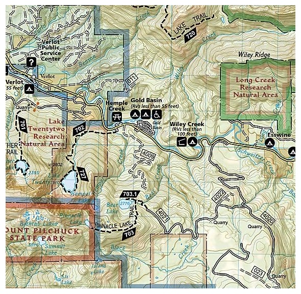
One of the most essential characteristics of a good trail map is a clear and accurate representation of the trail.
Topographic maps are commonly used for hiking trails as they reveal the terrain and points of interest. They allow hikers to gauge the hike's difficulty and help them reorient themselves if they get lost.
A good trail map should include essential features such as contour lines, which help hikers understand the steepness of the terrain and changes in elevation.
By reading contour lines, hikers can identify landscape features like spurs, reentrants, saddles, and summits.
For example, a trail map for a mountainous hiking trail should accurately depict the elevation changes, steep sections, and prominent landmarks along the trail.
This information helps hikers prepare for the physical demands of the hike and anticipate the challenges they may encounter.
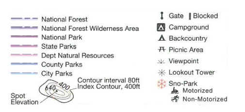
Easy-to-Read Symbols and Legends
Another essential characteristic of a good trail map is easy-to-read symbols and legends.
A well-designed trail map should have clear and intuitive symbols that are easily understandable.
Good design choices are essential when creating trail maps. Consideration should be given to the size, color, and shape of symbols to ensure they are distinguishable and do not cause confusion.
The map should also include a legend that explains the meaning of each symbol used.
Scale, Distance Measurements, and Topographic Information
Scale and distance measurements are essential aspects of a trail map. The scale indicates the relationship between the map and the real world, with smaller scales showing more detail.
A good trail map should have a suitable scale that provides enough detail for hikers to assess and plan for what lies ahead.
Topographic information is also crucial for hikers as it helps them visualize the hills, slopes, and mountains in three dimensions. Contour lines on the map represent changes in elevation and steepness of the terrain.
By understanding and reading contour lines, hikers can plan their routes, identify potential challenges, and select the most suitable trails for their skill level.
Digital and interactive maps are increasingly available from various sources, providing hikers with additional information such as elevation profiles, trail descriptions, and real-time updates on trail conditions.
These technological advancements enhance the hiker's experience and allow for more precise navigation.
For instance, a trail map for a long-distance hiking trail should include a detailed scale showing the distance between campsites, water sources, and other essential landmarks.
Additionally, topographic information should accurately represent the elevation changes along the trail, enabling hikers to anticipate steep sections or challenging terrain.
Landmarks, Points of Interest, and Trail Difficulty Ratings
A good trail map should include information about landmarks and points of interest along the trail.
This could include geologic features, historic sites, scenic viewpoints, waterfalls, or other notable attractions.
Including these landmarks and points of interest on the map helps hikers appreciate the natural and cultural significance of the area they are exploring.
Clear symbols or color-coded systems can represent different types of landmarks and points of interest.
In addition to landmarks, a good trail map should provide trail difficulty ratings.
These ratings help hikers assess the level of challenge and choose trails that match their fitness and skill level. The difficulty ratings can be represented using symbols, color coding, or a rating scale.
The trail map needs to include a legend that explains the meaning of the difficulty ratings used.
Trailhead Locations, Parking Information, and Intersections
Another essential characteristic of a good trail map is the inclusion of trailhead locations, parking information, and trail intersections.
Knowing where to access the trail and where to park can be crucial for hikers, especially if they are unfamiliar with the trail.
The trail map should indicate the starting points of the trail and provide information about parking facilities nearby.
Trail intersections are also essential to highlight on the map. These are points where the trail splits or intersects with other trails. Clear symbols or labels should be used to indicate these intersections, allowing hikers to navigate the trail system with ease.
It is also helpful to provide additional information or warnings related to trailheads and intersections, such as potential hazards or safety considerations.
Elevation Profiles, Trail Descriptions, and Directions
Including elevation profiles, trail descriptions, and directions on a trail map is another essential characteristic.
Elevation profiles provide a visual representation of the elevation changes along the trail, allowing hikers to anticipate steep climbs or descents.
This information is handy for planning and preparing for the physical demands of the hike.
Trail descriptions and directions help hikers navigate the trail with confidence. Clear and concise information about key landmarks, trail junctions, and notable features can guide hikers along the route.
Providing accurate and up-to-date trail descriptions and directions enhances the overall hiking experience.
/1004/site-assets/dateseal.jpg "Serving Seattle since 1950")
/1004/site-assets/creditcards.png)