/1004/site-assets/phone.png)
/1004/site-assets/cart.png)
Space: Mapping the Final Frontier
A Journey Through Space Mapping
This article overviews mapping space, including its definition, historical evolution, tools, technologies, a space geodesy project, mathematical concepts, and applications in various fields.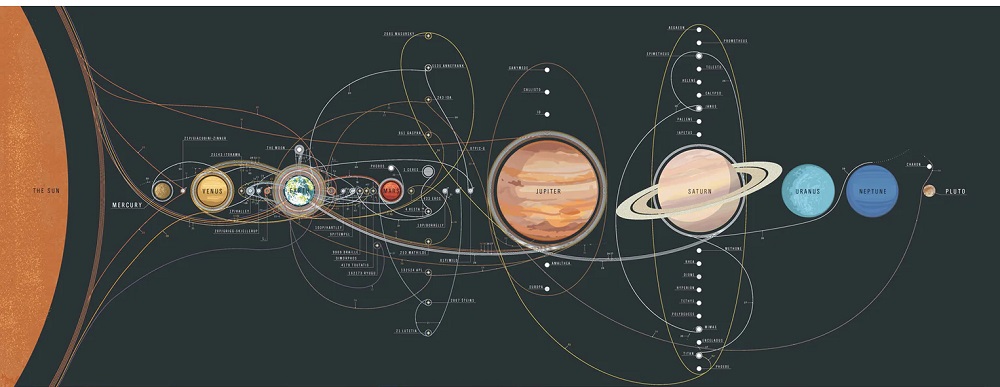
Space: Mapping the Final Frontier
It opens up a whole new realm of understanding, allowing us to uncover the cosmic secrets that have intrigued humanity for eons. Imagine charting the night sky, where stars, planets, and galaxies become more than just twinkling lights—they become destinations on our cosmic journey. Through space mapping, astronomers pinpoint the locations of these celestial wonders, leading to astonishing discoveries like distant exoplanets that might host alien life or witnessing the awe-inspiring spectacle of supernovae bursting in distant galaxies.
Engineers are also in on the fun, using space mapping to push the boundaries of technology in aerospace and biomedical fields. It’s like giving them a cosmic blueprint to optimize designs, enhance system functionality, and bring futuristic innovations to life. Whether it's designing cutting-edge spacecraft or developing life-saving medical devices, space mapping is their guiding star.
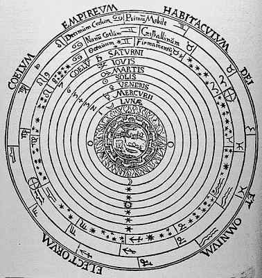
Now, let’s talk about celestial cartography and space exploration mapping—two fascinating aspects of space mapping that feel like stepping into a sci-fi novel! Celestial cartography, with roots reaching back to ancient Greek and Arab astronomers, has evolved into a sophisticated practice that maps the heavens with incredible precision. These ancient star maps laid the foundation for our modern techniques, blending the mystique of ancient stargazers with the precision of contemporary science.
As for space exploration mapping, it’s the ultimate adventure guide for our interplanetary quests. Imagine plotting the terrain of distant planets, identifying landing sites for future missions, and navigating the vast expanse of space with unparalleled accuracy. It’s like having a detailed map for a cosmic treasure hunt, guiding spacecraft through the solar system and beyond, uncovering the mysteries of planetary surfaces and the hidden secrets of the universe.
In essence, mapping space is a gateway to the stars, a tool that transforms the mysteries of the cosmos into a navigable, discover-able adventure, fueling our quest to explore, understand, and marvel at the wonders of the universe!
The story of space mapping begins with ancient civilizations like the Greeks and Arabs, who were the original celestial cartographers. The Greeks, with luminaries such as Ptolemy, laid down the early blueprints for charting the stars and planets, creating astronomical maps that became a cornerstone for future stargazers and explorers. Ptolemy's works, like the "Almagest," were monumental in plotting the heavens and influenced generations of astronomers to come.
Tools, Technologies, and Methodologies in Space Mapping
The advent of artificial neural networks has revolutionized space mapping methodologies. These networks can learn and recognize complex patterns within mapping data, creating efficient surrogate models that bridge the gap between coarse and fine models. In aerospace engineering, for instance, neural networks streamline the design process of aircraft components. They rapidly evaluate various design configurations and identify optimal solutions, significantly enhancing design efficiency and effectiveness. By integrating advanced technologies like neural networks, researchers can accelerate the exploration of unknown territories and deepen our understanding of the universe.
Through these historical and modern advancements in space mapping, we continue to unravel the mysteries of the cosmos, turning the once enigmatic night sky into a navigable and comprehensible domain. The journey from ancient star charts to advanced neural networks reflects our unending quest to explore and understand the universe in all its vastness.
Space Geodesy Project: Mapping Earth's Surface
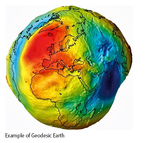
NASA's Space Geodesy Project is a groundbreaking venture in geodetic science, representing a monumental leap forward in mapping Earth's surface and monitoring its rotational dynamics. Central to this initiative is the use of cutting-edge technologies like Very Long Baseline Interferometry (VLBI), which provides incredibly accurate measurements of Earth's dimensions and spatial orientation.
These observations are vital for creating International Terrestrial and Celestial Reference Frames, essential tools that enhance the accuracy of GPS systems and other navigation technologies.
Moreover, the Space Geodesy Project exemplifies international collaboration, with NASA partnering with global entities to expand the capabilities of geodetic measurements. This cooperation fosters a unified approach to understanding Earth's geophysical properties and addresses complex challenges that affect the entire planet.
In essence, NASA's Space Geodesy Project not only advances scientific research but also brings practical benefits that touch various aspects of modern life. By pushing the frontiers of geodetic science, it paves the way for innovations that improve our understanding of Earth and the cosmos, ultimately contributing to a better, more navigable world.
A Few Final Words
In conclusion, geodesy is the unsung hero of our quest to understand and navigate Earth and space. Mapping space plays a pivotal role in this endeavor, offering essential insights into Earth's shape, orientation, and dynamic behavior. These cosmic maps are not just about charting stars or plotting celestial paths; they provide the foundational data for everything from accurate GPS navigation to predicting natural disasters.
As we look to the future, advancements in map technology promise to revolutionize our exploration of both terrestrial and extraterrestrial frontiers. Enhanced precision in space maps will propel scientific research, improve navigation systems, and even guide us in exploring distant planets. The fusion of geodesy with cutting-edge technology will continue to unlock new dimensions of our universe, making the cosmos more navigable and comprehensible than ever before.
/1004/site-assets/dateseal.jpg "Serving Seattle since 1950")
/1004/site-assets/creditcards.png)