/1004/site-assets/phone.png)
/1004/site-assets/cart.png)
The Significance of Pacific-Centered Maps
The world offers diverse perspectives, and the various World Map Projections showcase just that!
While Europeans are accustomed to maps centered on their region, have you ever considered putting Australia in the spotlight for a change?
In this article, we will begin an extensive exploration of Pacific Centered maps in cartography, encompassing their definition, distinct viewpoint, historical importance, strengths, weaknesses, and accessibility for study and exploration purposes.
Overview of Pacific-Centered Maps
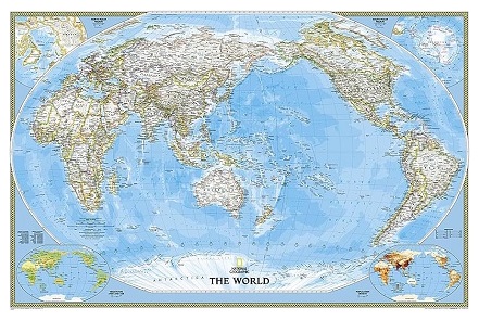
A Pacific Centered map is a distinct map projection that places the Pacific Ocean at the center, with a focus on Asia, Oceania, and the Pacific Rim, providing a unique and alternative view of the world compared to traditional map projections that often emphasize the Atlantic Ocean and the Western world. This map projection is significant in the field of cartography as it challenges the Eurocentric view commonly found in traditional map projections, offering a different perspective that is valuable for understanding global geography and relationships.
Understanding different map projections is essential as they are crucial in shaping global perspectives and perceptions of geographic relationships. By centering the Pacific Ocean, the Pacific Centered map highlights the vastness and importance of this region, shedding light on its historical, cultural, and economic significance. It provides a valuable perspective that differs from the more commonly used map projections, contributing to a more comprehensive understanding of the world's geography and the interconnections between regions. Furthermore, the historical and cultural significance of Pacific-centered maps is evident in their impact on cartography and global perceptions of the world, making them an intriguing subject for exploration and study.
Understanding Pacific-Centered Maps
The Pacific Centered map, as the name suggests, places the Pacific Ocean at the center, with a focus on Asia, Oceania, and the Pacific Rim. In contrast to traditional map projections that center on Europe or the Americas, the Pacific Centered map offers a unique world perspective, accentuating the vast expanse of the Pacific Ocean and the surrounding regions. This alternative view provides a fresh understanding of global spatial relationships and emphasizes the significance of the Pacific region in geopolitical, economic, and environmental contexts.
One of the most notable criticisms of the Pacific Centered map is its distortion of land masses, particularly near the edges of the map. This distortion can misrepresent the actual size and shape of continents and countries, potentially leading to misconceptions about the relative scale of different regions. For example, the Mercator projection, commonly used in many traditional maps, significantly enlarges countries situated closer to the poles, diminishing the size of equatorial regions. This has sparked debates about the potential implications of using map projections that may inadvertently perpetuate geopolitical, cultural, and economic biases. Our article on map projections helps explain some of the pros and cons of different projections.
Advantages and Disadvantages of Pacific-Centered Maps
One of the advantages of using a Pacific-centered map is its unique focus on the Pacific Rim and surrounding regions. This specific emphasis on the Pacific Ocean, Asia, and Oceania can be particularly valuable for understanding the interconnectedness of countries and regions in this part of the world.
For example, when examining trade routes, cultural exchanges, or geopolitical relationships, a Pacific-centered map can provide a comprehensive view that highlights the significance of the Pacific Rim as a distinct geographical and geopolitical entity.
However, the Pacific-centered map has its disadvantages. One notable drawback is the distortion of land masses, particularly near the edges of the map. This distortion can lead to misrepresentations of the relative sizes and shapes of continents and countries, affecting the accuracy of spatial understanding. Critics argue that this distortion can lead to misconceptions about the true scale of land masses, which can be misleading for educational and reference purposes.
Therefore, while the unique focus of the Pacific-centered map is advantageous for specific purposes, it's essential to acknowledge and consider the trade-offs it presents in terms of accuracy and representation of global geography.
Historical and
Cultural Significance
of Pacific-Centered Maps
The historical and cultural significance of Pacific-centered maps can be traced back to their influence on cartography and global perspectives.
These maps have provided a unique viewpoint that focuses on the Pacific Rim and surrounding regions, which has in turn affected the way people perceive the world. For example, the emphasis on the Pacific Ocean and the regions around it has led to a greater awareness of the interconnectedness of Asia, Oceania, and the Americas, highlighting the significance of these areas in global geopolitics, trade, and cultural exchange.
Furthermore, using Pacific-centered maps has also sparked discussions about the representation of different continents and countries. By centering the map on the Pacific Ocean, it has challenged the traditional Eurocentric view of the world, prompting a reevaluation of how different cultures and regions are depicted and understood.
This shift in perspective has contributed to a more inclusive and diverse approach to representing the world, acknowledging the importance of previously overshadowed areas in conventional map projections. Understanding the historical and cultural significance of Pacific-centered maps is essential for recognizing the impact of different map projections on shaping global perceptions and fostering a more comprehensive understanding of the world's interconnectedness.
/1004/site-assets/dateseal.jpg "Serving Seattle since 1950")
/1004/site-assets/creditcards.png)