/1004/site-assets/phone.png)
/1004/site-assets/cart.png)
Birdseye Maps & the Shaping of Cities
Maps in Urban Planning and Development
Birdseye maps, also known as aerial maps, play a crucial role in urban planning and development by providing a top-down view of urban areas, aiding in spatial analysis and city development. By offering detailed perspectives, birdseye maps have significantly influenced how urban planners visualize and strategize city layouts, ultimately enhancing decision-making processes related to urban infrastructure and growth.
The historical use of birdseye maps dates back to the 16th century when they were hand-drawn to represent urban areas from an aerial perspective. Over time, technological advancements have transformed these maps into high-resolution digital formats, enabling planners to analyze cities in intricate detail.
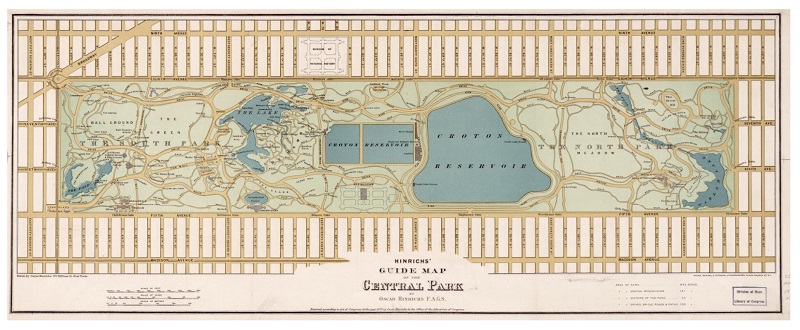
For instance, in the development of New York City's Central Park, birdseye maps were instrumental in visualizing the integration of an ample green space within the urban fabric, showcasing the significance of such maps in urban design.
Moreover, the benefits of utilizing birdseye maps extend beyond visual representation. These maps assist in identifying suitable locations for new infrastructure projects, such as transportation hubs or commercial centers, by analyzing the existing urban layout.
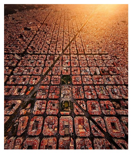
Another example, in the city of Barcelona, birdseye maps were pivotal in planning the expansion of the metro system to connect densely populated neighborhoods, showcasing how these maps aid in efficient urban development.
History of Birdseye Maps in Urban Planning
The history of birdseye maps in urban planning is a fascinating journey that began in the 16th century and has since evolved remarkably. Initially
conceptualized as a way to visualize cities from a unique perspective, birdseye maps have become indispensable tools for urban planners seeking to understand and develop urban environments. Notable cartographers and artists like Albert Ruger and Thaddeus Fowler were pioneers in creating birdseye maps, contributing significantly to their popularity and utility in urban planning.
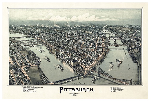
For instance, Albert Ruger's intricate birdseye maps of cities like Dover and Hartford gave urban planners detailed representations of city layouts, including street patterns, building locations, and open spaces. These maps not only served as visual aids but also as strategic tools for envisioning future developments and infrastructure projects within urban areas. Similarly, Thaddeus Fowler's birdseye views of cities like New York and Pittsburgh offered planners a comprehensive perspective on the existing urban fabric, enabling them to identify opportunities for growth and improvement. Through their meticulous illustrations, these historical figures laid the foundation for integrating birdseye maps into urban planning practices, influencing the design and development of cities for generations to come.
Benefits of Birdseye Maps in Urban Development
Birdseye maps provide urban planners and developers with valuable insights into metropolitan areas, enabling them to identify vacant land suitable for potential development projects. In Chicago birdseye maps have been instrumental in pinpointing underutilized spaces that can be repurposed for residential or commercial purposes, contributing to the city's economic growth and revitalization efforts.
By leveraging the detailed perspectives offered by birdseye maps, city officials can make informed decisions about land use and development strategies, ensuring efficient utilization of urban space.
Moreover, the visualization capabilities of birdseye maps extend to analyzing urban sprawl patterns and population density distribution, which are crucial aspects of effective city planning.
For instance, in Los Angeles, birdseye maps have been used to study the expansion of suburban neighborhoods and the concentration of population in certain areas, guiding policymakers in implementing zoning regulations and infrastructure improvements to support sustainable urban growth. This data-driven approach facilitated by birdseye maps enhances cities' overall resilience and livability by proactively enabling planners to address population trends and spatial dynamics.
Furthermore, the accessibility of birdseye maps to stakeholders and the public promotes transparency in urban development initiatives, allowing for meaningful engagement and feedback from the community to shape the future of cities collaboratively.
Influence on City Layouts and Infrastructure Design
Birdseye maps have played a pivotal role in shaping modern cities' layout and infrastructure design.
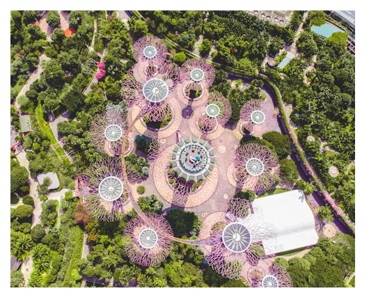
One prominent example of how birdseye maps have influenced city planning is the case of Singapore. By utilizing high-resolution aerial imagery and birdseye maps, Singapore's urban planners have strategically planned the city's infrastructure layout. The integration of birdseye maps has allowed Singapore to optimize the placement of green spaces, such as parks and gardens, within its urban fabric. This deliberate emphasis on green spaces enhances the city's aesthetic appeal and contributes to environmental sustainability by promoting biodiversity and mitigating urban heat island effects.
Moreover, birdseye maps have revolutionized the planning of transportation systems in cities like Amsterdam. The Dutch capital is known for its extensive network of cycling paths and efficient public transportation systems. Birdseye maps have provided urban planners in Amsterdam with valuable insights into traffic flow patterns and neighborhood connectivity.
By analyzing birdseye maps, Amsterdam has successfully created a transportation infrastructure that prioritizes pedestrian and cyclist safety, leading to a more inclusive and accessible urban environment. The integration of birdseye maps in the design of Amsterdam's transportation systems exemplifies how aerial perspectives can drive innovative solutions for urban mobility challenges, ultimately enhancing the quality of life for residents.
In addition to influencing green spaces and transportation networks, birdseye maps have also played a crucial role in developing sustainable urban infrastructure projects.
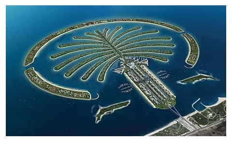
For instance, in Dubai, birdseye maps have been instrumental in planning and executing ambitious architectural projects like the Palm Jumeirah. By leveraging aerial perspectives, urban designers in Dubai have been able to visualize the integration of residential, commercial, and recreational spaces harmoniously and sustainably.
The precision offered by birdseye maps has enabled Dubai to construct iconic structures while preserving the natural landscape and waterfront areas, showcasing how aerial maps can facilitate the creation of resilient and environmentally conscious urban developments.
Challenges and Limitations of Using Birdseye Maps for Urban Planning
One significant challenge in utilizing birdseye maps for urban planning is the susceptibility of the accuracy of these maps to various external factors. Weather conditions like cloud cover, fog, or precipitation can obstruct the view from aerial cameras or satellites, compromising image quality and data reliability. For instance, during severe weather events, such as storms or heavy rainfall, capturing clear and accurate birdseye images becomes challenging, hindering urban planners' ability to assess and strategize effectively.
Interpreting birdseye maps demands high expertise in spatial analysis and geographic information systems (GIS). Urban planners and developers need specialized skills to extract meaningful insights from the visual data provided by birdseye maps. Understanding spatial relationships, identifying patterns, and making informed decisions based on the information presented in these maps require data analysis and interpretation proficiency.
Without the necessary expertise, there is a risk of misinterpretation, leading to flawed urban planning strategies and development initiatives.
Another limitation of using birdseye maps in urban planning is the challenge of scaling these maps for large metropolitan areas. Maintaining detailed resolution and accuracy across expansive urban landscapes can be complex and resource-intensive. As cities grow in size and complexity, ensuring that birdseye maps provide clear, high-resolution images of every corner becomes increasingly demanding.
This scaling challenge can impede the effective utilization of birdseye maps for comprehensive urban development projects, especially in megacities with intricate infrastructural networks and diverse land use patterns.
Role of Aerial Maps in Urban Design and Development
Aerial maps, with their ability to capture real-time data, have revolutionized the field of urban design and development. Using aerial maps, urban planners can closely monitor urban growth and identify areas susceptible to environmental risks such as flooding, landslides, and erosion. For instance, in Los Angeles, aerial maps have been instrumental in identifying regions prone to wildfires, enabling city authorities to implement adequate preventive measures and emergency response plans. This proactive approach to urban planning, driven by insights from aerial maps, highlights the crucial role they play in enhancing the resilience of cities against natural disasters.
Moreover, in urban design projects, aerial maps serve as valuable tools for assessing land use patterns and optimizing the allocation of resources to promote sustainable development.
For example, in Singapore, aerial maps have been utilized to analyze the spatial distribution of green spaces, residential areas, and commercial zones, creating a more balanced and eco-friendly urban environment. By incorporating data from aerial maps into the decision-making process, urban planners can make informed choices that support the population's well-being and the surrounding ecosystem.
This strategic use of aerial maps underscores their significance in shaping the future of urban landscapes toward a more sustainable and harmonious coexistence between urban development and nature.
/1004/site-assets/dateseal.jpg "Serving Seattle since 1950")
/1004/site-assets/creditcards.png)