/1004/site-assets/phone.png)
/1004/site-assets/cart.png)
Benchmark Souvenir Markers and "Peak Bagging"
What is a benchmark or survey marker?
A benchmark or survey marker is a permanently affixed point established by surveyors to provide a known, standardized point of reference for mapping and surveying activities.
These markers are often small metal disks set into rock, concrete, or other durable materials. They are placed at specific elevations and locations. The markers provide critical data on latitude, longitude, and altitude. They can then be used for topographic mapping, boundary surveys, and other geodetic or land management tasks.
They are typically installed and maintained by governmental agencies or recognized surveying organizations.
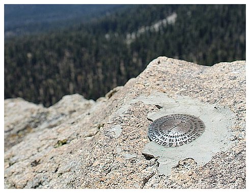
These benchmarks are reliable and designed to last for long periods, sometimes decades or centuries, so they are constant reference points. Each marker usually has information stamped on it, such as the agency responsible for its installation, an identification code, and sometimes the elevation above sea level.
GPS technology has modernized the field of surveying.
However, physical benchmarks are crucial, especially for calibrating and validating satellite-derived data.
What is "Peak Bagging"?
Peak bagging, on the other hand, is an outdoor activity that involves climbing to the summits of a collection of peaks, usually according to specific criteria like height, location, or a challenge list.
For example, in the United States, "Fourteeners" refers to peaks that rise over 14,000 feet; peak baggers might aim to climb all the Fourteeners in Colorado.
In the United Kingdom, "Munro Bagging" refers to the practice of climbing all the Munros, which are Scottish peaks over 3,000 feet.

Peak bagging combines elements of hiking, mountaineering, and sometimes even rock climbing, depending on the difficulty of the peaks involved.
Those who engage in this activity often keep detailed records of their climbs, sometimes noting the specific route taken, weather conditions, companions, and other data.
Some even use GPS devices to validate their claims, and in doing so, they might encounter benchmarks or survey markers at or near the summit.
This way, peak baggers and surveyors sometimes cross paths, metaphorically and literally.
How are "Peak Bagging" and survey markers connected?
While benchmarks serve a functional, scientific purpose to provide accurate cartographic and geodetic data, peak bagging is more recreational and personal, often driven by a love for the outdoors, adventure, or a desire to complete a specific challenge.
However, both contribute to our understanding and appreciation of geographical spaces.
Replica's of benchmarks are very popular with climbers and "peak baggers" to commemorate their ascent or achievement!
/1004/site-assets/dateseal.jpg "Serving Seattle since 1950")
/1004/site-assets/creditcards.png)